


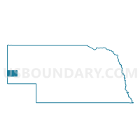
Long Springs Precinct, Banner County, Nebraska
About
Outline

Summary
| Unique Area Identifier | 612433 |
| Name | Long Springs Precinct |
| County | Banner County |
| State | Nebraska |
| Area (square miles) | 746.27 |
| Land Area (square miles) | 746.11 |
| Water Area (square miles) | 0.15 |
| % of Land Area | 99.98 |
| % of Water Area | 0.02 |
| Latitude of the Internal Point | 41.53974950 |
| Longtitude of the Internal Point | -103.72626260 |
Maps


Graphs
Select a template below for downloading or customizing gragh for Long Springs Precinct, Banner County, Nebraska


Neighbors
Neighoring Voting District (by Name) Neighboring Voting District on the Map
- ALBIN COMMUNITY CENTER Voting District, Laramie County, WY
- Antelope Precinct, Kimball County, NE
- Bushnell Precinct, Kimball County, NE
- Castle Rock A Precinct, Scotts Bluff County, NE
- Castle Rock B Precinct, Scotts Bluff County, NE
- Dix Precinct, Kimball County, NE
- Gering Precinct, Scotts Bluff County, NE
- Kiowa-Lyman Precinct, Scotts Bluff County, NE
- LA GRANGE OUTSIDE Voting District, Goshen County, WY
- Potter Precinct, Cheyenne County, NE
- Redington Precinct, Morrill County, NE
- Roubadeau Precinct, Scotts Bluff County, NE
- West Bayard Precinct, Morrill County, NE
Top 10 Neighboring County Subdivision (by Population) Neighboring County Subdivision on the Map
- Pine Bluffs CCD, Laramie County, WY (3,379)
- Gering precinct, Scotts Bluff County, NE (2,208)
- Goshen Hole CCD, Goshen County, WY (1,420)
- West Bayard precinct, Morrill County, NE (852)
- Kiowa precinct, Scotts Bluff County, NE (818)
- Long Springs precinct, Banner County, NE (690)
- Potter precinct, Cheyenne County, NE (644)
- Castle Rock precinct, Scotts Bluff County, NE (606)
- Antelope precinct, Kimball County, NE (588)
- Dix precinct, Kimball County, NE (434)
Top 10 Neighboring Place (by Population) Neighboring Place on the Map
Top 10 Neighboring Unified School District (by Population) Neighboring Unified School District on the Map
- Goshen County School District 1, WY (13,164)
- Gering Public Schools, NE (11,327)
- Laramie County School District 2, WY (5,540)
- Kimball Public Schools, NE (3,423)
- Morrill Public Schools, NE (2,510)
- Bayard Public Schools, NE (2,378)
- Potter-Dix Public Schools, NE (1,051)
- Banner County Public Schools, NE (747)
Top 10 Neighboring State Legislative District Lower Chamber (by Population) Neighboring State Legislative District Lower Chamber on the Map
Top 10 Neighboring State Legislative District Upper Chamber (by Population) Neighboring State Legislative District Upper Chamber on the Map
- State Senate District 48, NE (33,594)
- State Senate District 47, NE (32,377)
- State Senate District 49, NE (31,705)
- State Senate District 6, WY (19,877)
- State Senate District 3, WY (16,330)
Top 10 Neighboring 111th Congressional District (by Population) Neighboring 111th Congressional District on the Map
Top 10 Neighboring Census Tract (by Population) Neighboring Census Tract on the Map
- Census Tract 20, Laramie County, WY (7,130)
- Census Tract 9525, Morrill County, NE (5,042)
- Census Tract 9545, Kimball County, NE (3,821)
- Census Tract 9548, Cheyenne County, NE (3,157)
- Census Tract 9580, Goshen County, WY (3,015)
- Census Tract 9532, Scotts Bluff County, NE (1,524)
- Census Tract 9540, Banner County, NE (690)
Top 10 Neighboring 5-Digit ZIP Code Tabulation Area (by Population) Neighboring 5-Digit ZIP Code Tabulation Area on the Map
- 69341, NE (11,165)
- 69145, NE (3,214)
- 69336, NE (2,466)
- 69334, NE (2,351)
- 82082, WY (1,606)
- 69156, NE (699)
- 82221, WY (635)
- 69352, NE (619)
- 69345, NE (455)
- 82050, WY (401)